
Bellway have now submitted a planning application for the Phase 2 of the Golborne Road development. The application number is 2026/01220/HYB, details can be found on the WBC Planning portal at https://online.warrington.gov.uk/planning/index.html?fa=getApplication&id=216551
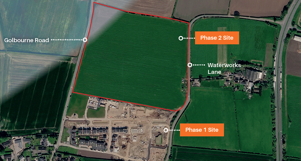
We understand that proposed developments of this scale generate significant community interest. We want to provide immediate clarity to residents on where this proposal currently sits within the planning process and how the Parish Council is responding.
Current Status: Full Planning Application
According to the materials submitted, the proposals are to:
- Deliver 228 new homes, including 45% affordable housing.
- Include two new vehicular access points directly from Golborne Road.
- Provide open space, landscaping, and an enhanced buffer along the northern boundary.
The Parish Council’s Next Steps
As with previous large-scale planning proposals in our area, the Parish Council is revewing the material and has produced a guide for residents to use while reviewing the application. We have also collected some useful material for including in any objection
- Guide while raising concerns about the development is available here
- Guide to developments taking place around the area and how to raise an effective objection is available here
- How to write an effective representation is available here
- Material vs Non-Material considerations is here
You can submit your representation through the online planning portal, by email to devcontrol@warrington.gov.uk or by letter to the WBC office at Times Square (you can deliver in-person).
The view of Parish Councillors is that there are serious concens with the development. While acknowledging the local housing supply shortfall, the Parish Council maintains that housing targets do not override national and local planning policies or justify granting permission without fully assessing its wider impacts on:
1. Green Belt & Conflict with the Local Plan
The site sits outside the established built-up area of Winwick, risking the erosion of the village’s rural setting, distinct identity, and the spatial strategy set out in Warrington’s adopted Local Plan.
- National Policy Compliance: The applicant must prove whether the site genuinely qualifies as “Grey Belt” and demonstrate compliance with all national policy tests for Green Belt release.
- Sustainable Location: Warrington Borough Council must explicitly evaluate whether this is a sustainable location for 229 homes and weigh the harm caused by departing from the Local Plan.
2. Highway Capacity, Congestion & Road Safety
Golborne Road and surrounding corridors already struggle with heavy residential, business, and school traffic, especially during morning and evening peak hours.
- Critical Junctions: Key pressure points—including Golborne Road/Myddleton Lane, Golborne Road/A49 Newton Road, and the wider A49 corridor—require rigorous independent technical scrutiny.
- Local Safety Evidence: The highway analysis must reflect local residents’ lived experiences of congestion and near-misses, rather than solely relying on recorded collision statistics.
3. Failure to Adequately Assess Cumulative Development
The application is being considered in isolation despite unprecedented levels of residential and logistics growth planned across north Warrington, St Helens, and Wigan.
- Cross-Boundary Pressures: The transport assessment ignores or underestimates combined traffic from major developments such as Bellway Phase 1, Peel Hall, Parkside Phases 1 and 2, Tritax’s Intermodal Logistics Park, and housing schemes around Newton-le-Willows, Croft, Culcheth, and Burtonwood.
- Freight Impact: Traffic modelling must realistically account for overlapping delivery schedules between heavy commercial logistics vehicles and commuter traffic.
4. Pedestrian Safety, Cycling & Accessibility
The proposed pedestrian and cycle links connecting the development to everyday services are deemed unsafe, impractical, and discontinuous.
- Green Lane Concerns: Suggested walking routes to bus stops on the A49 via Green Lane are narrow, unlit, lack adequate footways, and are unsuitable for children, the elderly, or wheelchair users.
- Route Audits: A thorough, practical audit is needed to establish safe, well-lit, continuous walking and cycle routes to schools and local facilities, rather than relying on purely theoretical map distances.
5. Public Transport & Reliance on Private Cars
Given the documented decline in local bus routes over the past decade, future residents will be forced into high car dependency.
- Outdated Transport Data: The applicant’s transport documents cite outdated bus frequencies and refer to destinations that are no longer operational.
- Enforceable Commitments: Any Travel Plan must offer legally binding, funded improvements to local bus services rather than wishful assumptions about car reduction.
6. Strain on Local Infrastructure & Services
The rapid scale of surrounding development is outstripping existing public services, placing an unfair burden on the Winwick community.
- Schools & Healthcare: Clear evidence must be provided that local GP surgeries, school places, and utilities have the capacity to handle hundreds of new residents.
- Parish Facilities: The Parish Council will submit a separate document looking at improvements it believes need to be secured if the proposal was approved in order to cope with the increased demand from residents.
7. Flood Risk, Drainage & Altered Land Levels
Introducing roads, rooftops, and hardstanding will alter surface water runoff across the site, heightening flood risks for adjacent homes.
- Technical Scrutiny: Independent engineers must verify that the proposed sustainable drainage system (SuDS) can handle severe storm events with climate change allowances.
- Ground Levels: Confirmation is needed that planned changes to site topography and discharge rates will not cause water displacement onto neighbouring land.
8. Landscape, Rural Character & Ecology
The development permanently urbanises a greenfield site, harming the traditional open landscape and biodiversity of the village edge.
- Biodiversity Net Gain: Independent reviews are necessary to safeguard hedgerows, mature trees, habitat corridors, and protected wildlife species.
- Mitigation Limits: Cosmetic planting schemes cannot act as an automatic substitute for the outright destruction of countryside character.
9. Heritage & Archaeology
Winwick has a rich historic environment, and any development must respect both designated and non-designated heritage assets.
- Archaeological Scrutiny: Thorough archaeological surveys and assessments of how the scheme affects the wider historic village setting must be completed prior to any planning decision.
10. Construction Disruption
If approved, years of building works will inflict severe disruption on existing neighbourhoods.
- Traffic & Environmental Management: A strict Construction Traffic Management Plan (CTMP) must be legally secured to ban construction HGVs from narrow residential streets, limit working hours, and control noise, dust, and silt runoff.
11. Unreliable Baseline Data in the Application
Multiple errors and inaccuracies in the applicant’s Transport Assessment undermine the credibility of their findings.
- Flawed Evidence Base: Errors regarding local street names, defunct destinations, and non-existent pedestrian links show a clear lack of local grounding, requiring the highway authority to discount flawed assumptions before proceeding.
The Parish Council discussed the development at it’s October meeting and will be submitting an objection to the development on these grounds.